|
Originally published in omaliprincipeen.weebly.com, know more here In April, we started a maturity study of the Golden African Snapper (Lutjanus fulgens) in partnership with Forever Principe - a conservation tourism program by Africa's Eden. This predatory species is one of the four snapper species of the genus Lutjanus that exist in Principe’s waters, and there's no information on its growth, diet or reproductive biology. As other snappers, Lutjanus fulgens probably reproduces through spawning aggregations, which makes it especially sensitive to overfishing. Through this study, we aim to better understand the biology of this species. When fishers arrive from fishing, four traders buy the fish from them and send it to the laboratory at Belo Monte, where we take samples of the gonads, fins, otoliths and stomach content. The samples will be taken to the University of Exeter for a histological analysis, to determine the maturity stage of the fish and its age, amongst other variables. This study will be done over several months and this information will be useful for a better management of Principe’s fisheries. 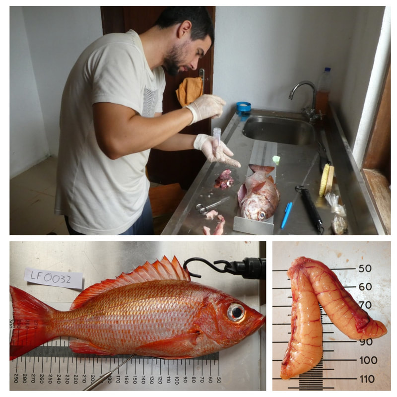
0 Comments
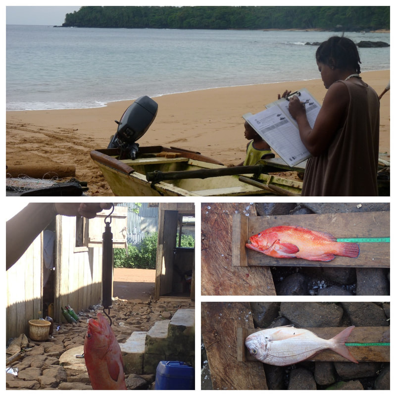
Originally published in omaliprincipeen.weebly.com, know more here Omali Vida Nón was invited to participate remotely in the international seminar "Biodiversity - Contributing towards diversifying Angola's economy". The event took place in the Geographic and Cadastral Institute of Angola (IGCA, Luanda) during the 27th and 28th of February and it was organised by the Portuguese organisation Biota Lda. This way, we continue to communicate the participatory approaches and methodologies used in Omali, so they can be used as a reference internationally. You can watch the presentation here: https://youtu.be/5SEOE-9vOwY (English subtitles available). Originally published in omaliprincipeen.weebly.com, more info here Omali Vida Nón’s team has been collecting fisheries landing data since December 2016; this work is being done by six focal points from the project’s fishing communities. Twice a week (every Tuesday and Friday), they get information about the number, weight and length of animals caught by fishers, as well as fishing gear and grounds used. During the dry season (“gravana”, June-September), we have been working closely with the focal points to support their work and find ways of improving data collection. On the 5th of October, we’ve organized a refresher training session and launched a new questionnaire for the landing surveys, so as to get more detailed information about fishing in Príncipe. We have also started producing short summaries using the fisheries landing data to return this information to the fishers. Originally published in omaliprincipeen.weebly.com, see more here. During the last 2 weeks, Baited Remote Underwater Video (BRUVs) stations were tested for the first time in Príncipe Island, with support from Dr Phil Doherty (University of Exeter, UK), who helped us setting-up and implementing this methodology. This non-invasive technique allows recording diversity, abundance and behaviour of marine species by attracting them into the field of view of an underwater camera with a bait. During Phil’s visit, different protocols were tested to identify the most suitable for Príncipe’s marine environment. Snappers, rays, sharks and many other species were recorded during this pilot! See a snapshot of Principe's marine life in video below. We are currently fundraising to continue this study in 2018 and better understand this unique marine environment - get in touch if you´d like to contribute. Originally published in omaliprincipeen.weebly.com, know more here. Materials can be downloaded here. Omali Vida Nón’s team participated in the “Technical Course on Ecotourism”, coordinating a 25h course on Cartography. During the classes, technical training was delivered on map reading, using elevation maps to plan routes, calculate distances in the map using the scale, orientation using the compass and mark coordinates from a GPS device in the map. Students had the opportunity to work with plenty of cartographic material of Principe created especially for the course and they even drew their own map of Santo Antonio city! This way, our project also contributes to the training and capacity development of conservation and tourism staff in Príncipe. 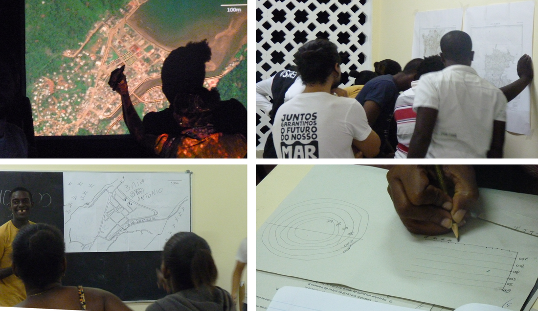 Originally published in omaliprincipeen.weebly.com, read more here After two months working with fishers, the Omali Vida Nón team has already produced preliminary maps of the artisanal fishing areas! Fishers have been carrying GPS trackers that record their location every time they go fishing. Copies of these maps have been offered to the fishers, along with an individual map in which fishers could see their fishing areas represented in the map. This information will allow us to identify the most important areas for the artisanal fishing communities in Principe and, for example, identify possible conflicts with industrial fishing. 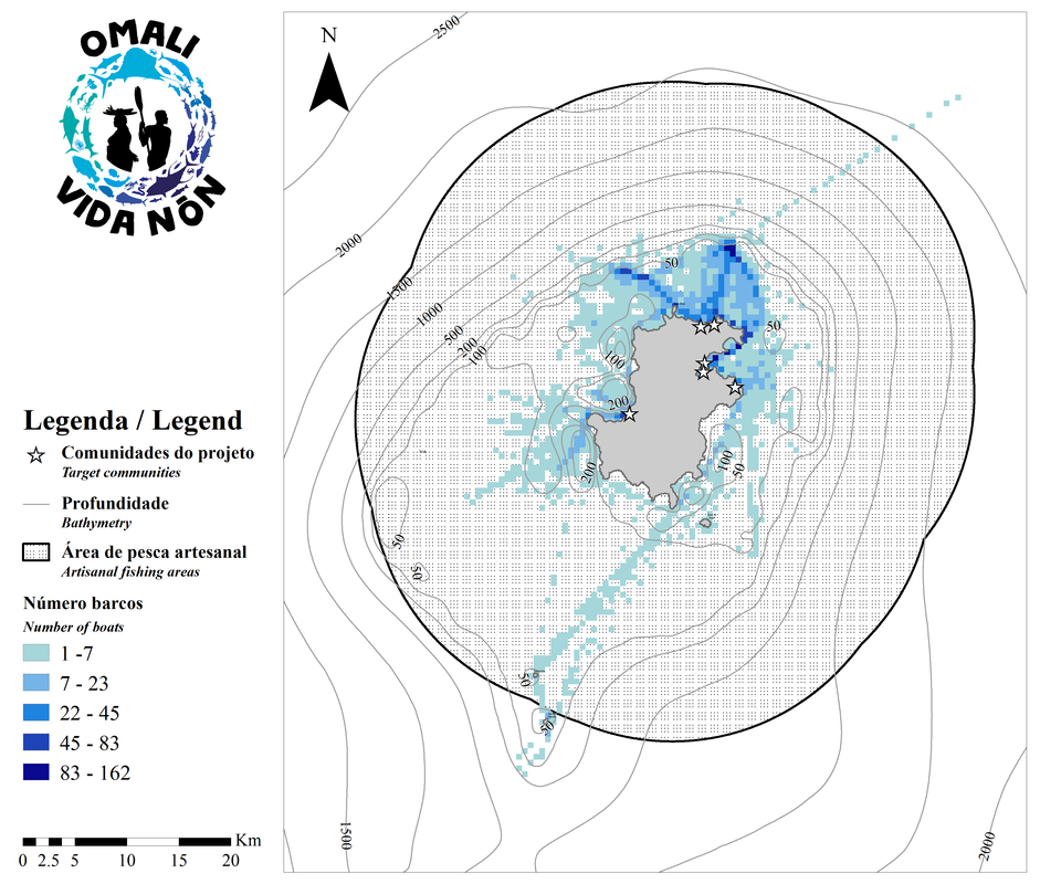 |